
All Routes
Walk overview
General Argentinian route information
Rio Villegas to the waterfall
- Buses and Rio Villegas
- Hiking along the Rio Manso road
- Suspension bridge across the manso
- Meadows and flatlands along the Rio Manso
- Fences to avoid on the Rio Manso
- Rio Manso - easy camping
- The waterfall marked on the map
The waterfall to the Argentine - Chilean border
- El Manso: Rafting campsite, restaurant and minimart
- Argentinian customs - Gendarmeria Nacional
- The case of the missing refugio
- Crossing the Argentina-Chile border
General Chilean route information
Paso El Leon to Torrentoso
- Chilean Carabineros, border crossing and the hamlet of El Leon
- A rangers' forest camp
- Conditions along the route
- The turn towards Torrentoso
Torrentoso to end of Lago Vidal Gormaz
- Torrentoso turning
- Camping at the south end of Lago Vidal Gormaz
- Along Lago Vidal Gormaz
- Food supplies at the north end of the lake
- Route to virgin rainforest
Lago Vidal Gormaz to La Junta
- Lakes in the rainforest
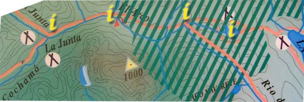
- Junction of two rivers and two paths
- El Arco refugio and natural bridge
- La Junta refugio

 The extended descent from the lakes leads to a fast flowing, but fairly narrow river. Around here, on the opposite bank, there's a sign to Lago Vidal ( pictured below ) with a log crossing very nearby. The log is difficult to reach without going through the river as it is down a 3' drop, a long way with full packs on. If you have difficulty finding the sign, put your packs down and scout, the main path restarts just past the sign on the opposite bank. It is clear that the path is a main one as it is well worn by horses taking the Rio de los Morros route to the east of this route. Rejoin the path heading north west. From here the path becomes increasingly muddy; this is roughly the half-way mark of the path through the virgin rainforest area.
