| Time of year |
Summer - Jan through April. Before this there may be snow along the route and the winds are incredibly forceful, and the rain forest section would probably be impassable due to the sitting water and high ice-melt river levels. |
| Getting to Cochamo |
Buses from Puerto Montt leave the main bus station at: 8:15, 10:15, 12:30, 16:15, 17:00 and 18:15. It costs 2000 pesos for a ticket to Cochamo. Ask the bus driver if they would stop for you at the road end - they probably will.
|
Customs information
 |
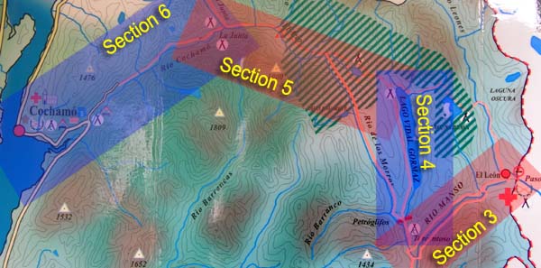
The Argentinian border guards are open any time of day, but there is a fee for out of hours services. They are quite friendly and there was no charge for our leaving the country ( there is a 30 pesos charge for crossing with a horse, we didn't have one ). The Chilean border guard didn't have hours posted, but as he lives in the house behind the office he is probably there at most times of the day. When coming to a large bridge after crossing the official border, continue straight (don't cross the bridge). Behind the hill with the school on it is a large clearing with the official Carabineros office. See Section three for photos of this area. There were no charges at either border, we are UK and US citizens. |
| Food availability |
Food is seasonally available in small amounts from Sonia and Manuel at the north end of Lago Vidal Gormaz ( see section 4 second 'i' from the left ), as well as other farms in the area, such as Campo Torrentoso (though Torrentoso didn't have any food when we passed through in early January). Cochamo has small supermarkets selling standard fare for reasonable prices. |
Maps
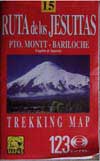 |
We have two maps that cover the area.
JLM Mapas Trekking Map #15 'Ruta de los Jesuitas ( Pto. Montt - Bariloche' ( ISBN none shown ). This shows the countours for the area and has a 1:250,000 scale. Unfortunately it doesn't show the route up to Lago Vidal Gormaz from either direction. While the contours and general detail are good enough for hiking the lack of trails makes it of dubious use for this hike. The other map, is the one we used for our hike and the map images shown on this site. It is updated every two years and it seems that every house along the route has a promotional copy. Where it's actually for sale we have yet to discover. If you have a digital camera, there is one of these maps posted on the door of the El Manso mini-mercado, and another on the inner wall of the Argentinian customs building. |
Scenery
 |
Manso river valley with thickly forested sides, high mountain lake of Vidal Gormaz, virgin rainforest ( with more lakes ), waterfalls, a chameleon inhabited swamp, classic southern Chilean farmland, gauchos, traditional cattle and trade routes and an entire valley made of massive granite cliffs. |
Annoyances
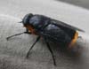 |
Damn big horse-flies. The really big black ones with the orange butts ( shown here ) go away when hit, and are pretty easy to hit on the whole, the smaller ones are more persistent and harder to hit, luckily there are fewer of them. The flies were quite bearable when we were there but there were far more on the Chilean side. Reportedly they get worse as the summer goes on. |
| Money |
There are no places to change money on the route, including Cochamo in Chile. It is best to change whatever you need for a few days before reaching the area, and keep at least 2000 pesos chilenos for the bus from Cochamo to Puerto Montt if that is the way you are going. Puerto Varas, a few km from Puerto Montt, is the closest place to change money. The farms along the route may accept payment in Argentine or Chilean pesos, or USD in return for food.
|