
All Routes
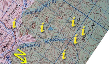
| Section 2: Click on the "i"s above for information and photos of the route. |
|


Only a half hour before reaching the pass (Abra Haurina), is a trickling spring ![]() that crosses the path with such little fanfare that only those in need of water will notice it. This water source is the first and last flowing water before reaching base camp (about an hour and a half away if no wrong turns are made.) Much more notable than the spring, is the first view of Inca Wasi nestled in the crook of one of the uppermost crags across the valley. (see photo on the right)
that crosses the path with such little fanfare that only those in need of water will notice it. This water source is the first and last flowing water before reaching base camp (about an hour and a half away if no wrong turns are made.) Much more notable than the spring, is the first view of Inca Wasi nestled in the crook of one of the uppermost crags across the valley. (see photo on the right)
The pass itself is also very understated. The moment the path starts to go downwards is the actual top of the pass ![]() . This is very hard to believe at first because only ten minutes walk, and in clear view is another pass marked with a cross and cairn. (see top photo) Ignoring the decorated pass, look to the right and over the top of a small bump you will find another large path leading down toward the head of the uppermost tributary of the Rio Palmayoc. (The picture below is Vincent Lee's 2004 expedition returning over Abra Huarina.) Follow this path around the north end (veering to the left, downwards behind the hills on the edge of the Palmayoc riverhead) through a flat section of pampas, short tussock grass, with a great view of the green valley to the north (see next section for photo).
. This is very hard to believe at first because only ten minutes walk, and in clear view is another pass marked with a cross and cairn. (see top photo) Ignoring the decorated pass, look to the right and over the top of a small bump you will find another large path leading down toward the head of the uppermost tributary of the Rio Palmayoc. (The picture below is Vincent Lee's 2004 expedition returning over Abra Huarina.) Follow this path around the north end (veering to the left, downwards behind the hills on the edge of the Palmayoc riverhead) through a flat section of pampas, short tussock grass, with a great view of the green valley to the north (see next section for photo).
