
All Routes
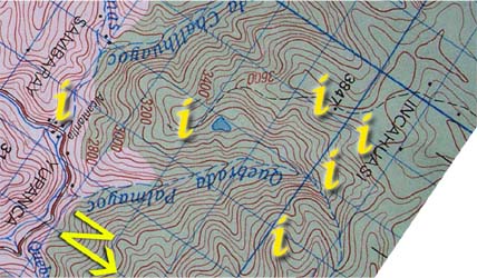
| Section 2: Click on the "i"s above for information and photos of the route. |
|

In the large clearing ![]() the path disappears, and two trailheads appear: one on the top of the clearing (correct path for continuing to Puncuyoc) and the other heads off to the right near the bottom of the clearing. The latter is easier to see and tempting after the climb, however, it only leads to the lagoon - a hour return walk - where green grassy fields, complete with a herd of cows, border the lagoon. It makes a nice campspot for those who are arriving at this point late in the day. (See photo: grassy spot on the right of the lagoon)
the path disappears, and two trailheads appear: one on the top of the clearing (correct path for continuing to Puncuyoc) and the other heads off to the right near the bottom of the clearing. The latter is easier to see and tempting after the climb, however, it only leads to the lagoon - a hour return walk - where green grassy fields, complete with a herd of cows, border the lagoon. It makes a nice campspot for those who are arriving at this point late in the day. (See photo: grassy spot on the right of the lagoon)

The path continues upwards for two more hours through cowfields of varying soggyness (some are campable, though wet and exposed) before reaching the first running water ![]() of the hike.
of the hike.