
All Routes
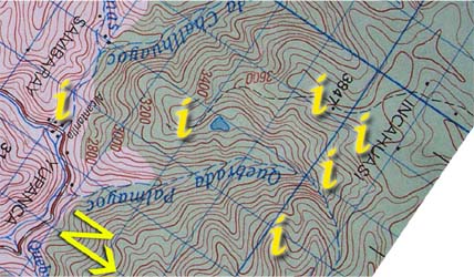
| Section 2: Click on the "i"s above for information and photos of the route. |
|
Terrain - The first four and a half hours of this section is up a steep trail to the top of the pass (abra Huarina). From there it is an hour and a half of downwards walking cross country through pampas grasses using the terrain, map and compass for navigation (and GPS if thickly clouded).
Water - There is no running water for the first four hours of the hike. Note, that this four hours only includes hiking time, and with rest stops it can take much more time to complete. It is also important to note that the spring is tiny! Not until basecamp is there a larger source of running water. It is important to note that there are many livestock animals in this area and all water should be carefully purified prior to drinking.
Notes - In bad weather, this area can become very difficult to navigate and negotiate. The windspeed at altitude can reach hurricane forces in severe storms, a point that has been discussed among the scientists as to a possible reason why Inca Wasi has such an elaborate system of roofing pegs and eyebonders.