
All Routes
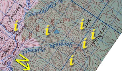
| Section 2: Click on the "i"s above for information and photos of the route. |
|

Continue through Yupanca, picking up petrol/kerosene, if needed, at the corner store before the bridge on the main street. Cross this bridge and directly afterwards leave the road on the path at the left ![]() . This is the main access point for trails leading from three parts of the local mountains, so only a few feet up the path there is a large split. Take the path on the right (red arrows) that starts to switchback up the slope immediately. (The blue arrows are an optional return route discussed in the hike details section.) There are two paths that wind their way up the mountain, a fairly gentle grassy and sometimes overgrown path, and a steep scree covered path that goes straight up the mountain. Using a combination of these two paths, it takes thirty five minutes to reach the forest where the two paths merge into one.
. This is the main access point for trails leading from three parts of the local mountains, so only a few feet up the path there is a large split. Take the path on the right (red arrows) that starts to switchback up the slope immediately. (The blue arrows are an optional return route discussed in the hike details section.) There are two paths that wind their way up the mountain, a fairly gentle grassy and sometimes overgrown path, and a steep scree covered path that goes straight up the mountain. Using a combination of these two paths, it takes thirty five minutes to reach the forest where the two paths merge into one.

The trail then climbs steeply upwards along the edges of forest patches for one and a quarter hours before emerging onto a large open, though very soggy and slopey field ![]() with great views of the Vilcabamba and Palmayoc (IGN map) / Upamayu (Vincent Lee's map) valleys. Inca Wasi is still hidden at this point.
with great views of the Vilcabamba and Palmayoc (IGN map) / Upamayu (Vincent Lee's map) valleys. Inca Wasi is still hidden at this point.