<!DOCTYPE HTML PUBLIC "-//W3C//DTD HTML 4.01 Transitional//EN">
<html lang="en">
<head>
	<title>Argentinian side of the Rio Manso hike</title>
	<meta name="KEYWORDS" content="argentina, chile, rio manso, manso, border, hike, walk, tramp, multi-day, foot border">
	<meta name="DESCRIPTION" content="Hiking route details of the route along the Rio Manso from Argentina to Chile">
	<link rel="stylesheet" type="text/css" href="../../../common_files/routes/overview.css">
	<meta http-equiv="Content-Type" content="text/html; charset=ISO-8859-1">
	<meta name="AUTHOR" content="Andy Leach and Dana Dopp Weniger">
	<link rel="stylesheet" type="text/css" href="../../../common_files/routes/general.css">
<script type="text/javascript" src="/google-analytics.js"></script></head>
<body>
	<div class="NavBar">
		<a href="../../../index.htm"><img src="../../../weblogosq.jpg" class="weblogosq" alt=" By land water and air Logo" title="By land, water and air homepage"></a>
		<br><a href="https://www.bylandwaterandair.com/samerica03/routes/">All Routes</a><h2><a href="index.php">Walk overview</a></h2>
<h3><a href="arg_main.php">General Argentinian route information</a></h3>
<h4>Rio Villegas to the waterfall</h4>
		<ol>
			<li><a href="s1_1_rio_villegas.php">Buses and Rio Villegas</a></li>
			<li><a href="s1_2_rio_manso_road.php">Hiking along the Rio Manso road</a></li>
			<li><a href="s1_3_rio_manso_bridge.php">Suspension bridge across the manso</a></li>
			<li><a href="s1_4_rio_manso_flat.php">Meadows and flatlands along the Rio Manso</a></li>
			<li><a href="s1_5_rio_manso_fences.php">Fences to avoid on the Rio Manso</a></li>
			<li><a href="s1_6_easy_camping.php">Rio Manso - easy camping</a></li>
			<li><a href="s1_7_waterfall.php">The waterfall marked on the map</a></li>
		</ol>
<h4>The waterfall to the Argentine - Chilean border</h4>
		<ol start="8">
			<li><a href="s2_1_el_manso.php">El Manso: Rafting campsite, restaurant and minimart</a></li>
			<li><a href="s2_2_argentinian_customs.php">Argentinian customs - Gendarmeria Nacional</a></li>
			<li><a href="s2_3_missing_refugio.php">The case of the missing refugio</a></li>
			<li><a href="s2_4_argentina_chile_border.php">Crossing the Argentina-Chile border</a></li>
		</ol>

<h3><a href="chile_main.php">General Chilean route information</a></h3>
	<h4>Paso El Leon to Torrentoso</h4>
			<ol start="12">
				<li><a href="s3_1_chilean_customs.php">Chilean Carabineros, border crossing and the hamlet of El Leon</a></li>
				<li><a href="s3_2_rangers_camp.php">A rangers' forest camp</a></li>
				<li><a href="s3_3_path_conditions.php">Conditions along the route</a></li>
				<li><a href="s3_4_torrentoso_turn.php">The turn towards Torrentoso</a></li>
			</ol>
		<h4>Torrentoso to end of Lago Vidal Gormaz</h4>
			<ol start="16">
				<li><a href="s4_1_torrentoso_turning.php">Torrentoso turning</a></li>
				<li><a href="s4_2_south_lago_vidal_gormaz.php">Camping at the south end of Lago Vidal Gormaz</a></li>
				<li><a href="s4_3_along_lago_vidal.php">Along Lago Vidal Gormaz</a></li>
				<li><a href="s4_4_new_supplies.php">Food supplies at the north end of the lake</a></li>
				<li><a href="s4_5_route_to_rainforest.php">Route to virgin rainforest</a></li>
			</ol>
		<h4>Lago Vidal Gormaz to La Junta</h4>
			<ol start="21">
				<li><a href="s5_1_confusion_lake.php">Lakes in the rainforest</a></li>
				<li><a href="s5_2_junctions.php">Junction of two rivers and two paths</a></li>
				<li><a href="s5_3_el_arco.php">El Arco refugio and natural bridge</a></li>
				<li><a href="s5_4_la_junta_refugio.php">La Junta refugio</a></li>
			</ol>
		<h4>La Junta to Cochamo</h4>
			<ol start="25">
				<li><a href="s6_1_la_junta.php">Granite cliffs and La Junta campground</a></li>
				<li><a href="s6_2_trail_conditions.php">Trail conditions along the last leg of the path</a></li>
				<li><a href="s6_3_gravel_road.php">End of the path from Argentina</a></li>
				<li><a href="s6_4_main_road.php">Main road to Cochamo and Campo Aventura</a></li>
				<li><a href="s6_5_cochamo.php">Cochamo and civilization</a></li>
			</ol>
</div>
<div class="MainArea">
<div class="background">
	<span class="map"><img src="overview_map.gif" width="250" height="300" alt="Overview map" border="0"></span>
	<span class="TopRight"><img src="overview_400x100.jpg" width="400" height="100" alt="Walking in the rainforest" border="0"></span>
	<span class="BottomRight"><img src="overview_200x200.jpg" width="200" height="200" alt="Lago Vidal Gormaz farmscape" border="0"></span>
	<span class="BottomLeft"><img src="overview_450x50.jpg" width="450" height="50" alt="Bahia Cochamo" border="0"></span>
	<span class="Island"><img src="overview_190x140.jpg" width="190" height="140" alt="Bog flower" border="0"></span>
<span class="TopLevelText">
<table>
<tr>
       <td><a href="index.php#duration">Duration</a>:</td>
       <td>7 days, 100km ( including 15km of road )</td>
</tr>
<tr>
       <td><a href="index.php#terrain">Terrain</a>:</td>
       <td>River valley, three low mountain passes</td>
</tr>
<tr>
       <td><a href="index.php#scenery">Scenery</a>:</td>
       <td>Traditional ranches, virgin rainforest, granite valley</td>
</tr>
<tr>
       <td><a href="index.php#highlights">Highlights</a>:</td>
       <td>Border crossing without roads, Lago Vidal Gormaz, La Junta granite</td>
</tr>
</table>
</span>
<span class="DetailAnchorLinks">
<table>
<tr>
       <td width="40%"><a href="index.php#transport">Transport to/from hike</a>:</td>
       <td>Bus</td>
</tr>
<tr>
       <td><a href="index.php#water">Potable water</a>:</td>
       <td>Mountain streams</td>
</tr>
<tr>
       <td><a href="index.php#food_to_buy">Food on route</a>:</td>
       <td>Seasonal and sparse</td>
</tr>
<tr>
       <td><a href="index.php#horses_and_guides">Horses and guides</a>:</td>
       <td>Available, not required</td>
</tr>
<tr>
       <td><a href="index.php#permits">Permits</a>:</td>
       <td>Passport, check <a href="http://www.lonelyplanet.com" title="Official Lonely Planet website">Lonely Planet</a> for visa requirements</td>
</tr>
<tr>
       <td><a href="index.php#accommodation">Accommodation</a>:</td>
       <td>Infrequent, bring tent</td>
</tr>
<tr>
       <td><a href="index.php#expenses">Expenses</a>:</td>
       <td>None required</td>
</tr>
<tr>
       <td><a href="index.php#equipment">Special Equipment</a>:</td>
       <td>Gaitors, if walking</td>
</tr>
<tr>
       <td><a href="index.php#annoyances">Annoyances:</a></td>
       <td>Horse-flies</td>
</tr>

</table>
</span>
</div>

<div class="details">
<h4><a name="duration">Duration</a></h4>
<p>This will vary hugely depending on fitness levels, gear carried and weather. The local advice is to build a day or two extra into your expectations in case of rain and high river levels. Most of the Chilean route, especially the rainforest section, would be challenging under such circumstances.  We took 9 days in all, starting at 9pm on the first day and ending at 10am on the final day.</p>

<h4><a name="terrain">Terrain</a></h4>
<p>Mixed. There are a great many climbs and descents on the route, doing it from Argentina to Chile is on average down ( though you would rarely know it ) and ends at sea level. The climbs are never technical and require no further equipment. We found it useful to have 2 sticks each the entire time, they helped greatly with the muddy climbs, the horse corrugations and the river and log crossings. They also take a great deal of strain away from ankles and knees, saving twists and knocks.  It is unusual to take many steps in a row without having to pay attention to where your feet are going, the meadow and road sections at either end are an exception to this.  While navigation of the route is fairly easy and the path is mostly well defined there are a few places to be aware of - these are detailed in the relevant sections. Map reading skills and a compass are essential.</p>

<h4><a name="scenery">Scenery</a></h4>
<p>
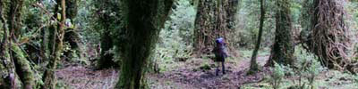
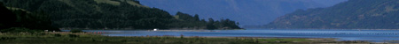
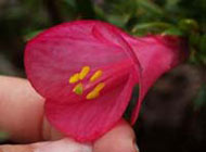
The walk starts with snow capped mountains on either side of a wide valley, a place where condors flew overhead in pairs.  After crossing the border and climbing away from the river valley, mountain lakes reflect the mountain peaks.  After leaving Lago Vidal Gormaz the trail is swallowed by virgin rainforest with huge trees and vines covered in ferns and mosses.  Small chameleons scampered along the path logs in an area of sunny swamp, changing color as they moved from under our approaching feet.  El Arco is a natural bridge over a waterfall nearing the end of the hike.  A single young Alerce tree (though possibly still hundreds of years old as these trees can live up to 4000 years) is growing on the natural bridge and will probably someday be its demise.  The forest gives way to a wide valley made of sheer granite hundreds of feet high.  This area has been described by an English mountain climber in a magazine as an undiscovered wonder.  After passing through some forested narrows the end of the hike greets the weary hiker with a view of a volcano reflected in an ocean fjord.</p>

<h4><a name="highlights">Highlights</a></h4>
<p>
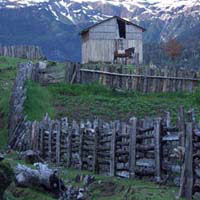
Crossing a country border where no cars are able to pass and the border guards are friendly and welcoming is a wonderful experience.  Drinking fresh warm milk and yerba mate while chatting with families who live in an area that is only accessible by horse and foot over three days.  Walking through a virgin temperate rainforest under giant fallen logs.</p> 

<h4><a name="transport">Transport</a></h4>
<p>For details on the transport to and from either end of the hike, click on Argentinian info or Chilean info on the left-hand bar of this page.</p>  

<h4><a name="water">Drinking water</a></h4>
<p>We filled our bottles directly from streams along the route - no filter, no iodine. We specifically chose streams that looked clear, had no cow prints etc in them and where the map showed no dwellings/farms upstream.  It tasted good and we didn't experience any problems.</p>

<h4><a name="food_to_buy">Food stuffs</a></h4>
<p>Argentina is significantly cheaper than Chile for most things, including food.  In Bariloche we bought polenta, queso rallado ( dried grated cheese, similar to parmesan ), grape seed oil (kept in a coke bottle), and powdered milk for breakfast and evening meal each day. Lunch was a block of cheese, 50g of walnuts, a muesli bar and half a Christmas 'Turr&oacute;n' bar ( a kind of peanut, egg-white and sugar concoction - some brands are good, some are <i>very</i> bad ).  The only other food we picked up was 6 eggs, 4 small loaves of bread and a &frac12; kilo of cheese at the north end of Lago Vidal Gormaz. (Spending a total of 4000 Chilean pesos).  We survived well and the meals didn't seem to get repetitive.<br><br></p>
<table>
	<thead>
		<tr><td>Breakfast and dinner</td><td>&nbsp;&nbsp;&nbsp;&nbsp;Lunch</td></tr>
	</thead>
	<tbody>
		<tr><td><img src="overview_polenta.jpg" width="147" height="149" alt="Image of breakfast and dinner showing Polenta, powdered milk, dried cheese, salt and grape oil" border="0" title="Image of breakfast and dinner showing Polenta, powdered milk, dried cheese, salt and grape oil"></td>
		<td><img src="overview_lunch.jpg" width="250" height="149" alt="Image of lunch showing walnuts, turr&oacute;n, muesli bars and cheese" title="Lunch - walnuts, turr&oacute;n, muesli bars and cheese" border="0"></td>
		</tr>
	</tbody>
</table>


<h4><a name="horses_and_guides">Horses and Guides</a></h4>
<p>Guides are available for the area. <a href="http://www.chile-travel.com/ca.htm" title="Campo Aventura website" target="_self">Campo Aventura</a> can provide horses and guides, there are others available locally in Chile and in Bariloche, Argentina.  We were offered horses as we passed through the farmland west of the Carabineros post in El Leon, Chile.  Horses are also available from El Manso - 30 pesos for a horse to the border.  If coming from Bariloche and wanting a guide it would be well worth contacting Ignacio Bustamente, a local, who speaks good english and regularly guides through this area. He is known and liked by the land owners en-route.</p>

<h4><a name="permits">Permits</a></h4>
<p>No permits are required to pass through this area. Passports and any relevant papers must be shown on both sides of the border. Check <a href="http://www.lonelyplanet.com" title="Official Lonely Planet site">Lonely Planet</a> or the websites of the countries to find out if your country has any special requirements.</p>

<h4><a name="accommodation">Accommodation</a></h4>
<p>We exclusively camped along the route, using free spots every night. Places are fairly easy to come by on the whole, the only difficulty is in the rainforest, which is steep and muddy - despite that spots can still be found. The campspots marked on the map can be tricky to find, we only found La Junta and the north end of Lago Vidal Gormaz. We stayed at neither of the sites we found simply because the timing was off or we had been invited elsewhere.  Marked campsites along the body of the walk are simply ground to put a tent on - there is nothing in the way of amenities in these areas.</p><p>We had been told by an argentinian guide in Bariloche that the locals will accommodate people for a few pesos per night.  There are refugios on the route, these offer shelter, a central fire pit and, in some cases toilets. They are free to use but you will still require sleeping bags, a mat and your own cooking equipment. It is unlikely that enough distance can be made on foot in one day to stay exclusively in refugios but between stays at locals and refugios a lighter pack, free of tent etc, might make it possible. A likely route might be: Rio Villegas-El Manso-El Leon-Torrentoso-North end of Lago Vidal Gormaz-El Arco refugio-La Junta refugio-Comacho. This assumes that every ranch and every refugio has space when you arrive, it also assumes that the weather remains clement to allow for rapid travel. </p>

<h4><a name="expenses">Expenses</a></h4>
<p>Along the trail there are no expenses for this hike - no park fees and no visa fees for US and UK citizens. </p>

<h4><a name="equipment">Special Equipment</a></h4>
<p>Gaitors are pretty essential if hiking this route.  The mud is often more than boot deep and several of the river crossings are more than knee deep in the dry season.  Gear links: <a href="../../../extras/hiking_gearlist.php" title="Standard hiking gear list">Standard hiking gear</a>, <a href="../../../extras/medkit.php" target="_self">Our medical kit</a>.</p>

<h4><a name="annoyances">Annoyances</a></h4>
<p>The only real annoyance is the horse-flies. In early January they are only really a pain if you stop in a sunny area - in the forest they are no problem at all. They are very temperature dependent, which makes for fly-free mornings and evenings. There were very few mosquitos, although around the old El Arco refugio there were plenty. As with the flies, their numbers probably build as the summer goes on.  We found the people friendly and helpful, we had no issues crossing anyone's land, in fact the path sometimes goes directly through farms so it is expected that you will pass through.</p>
<div class="AdBannerStatic"><script type="text/javascript">google_ad_client = "pub-0178259204611634";google_ad_width = 468;google_ad_height = 60;google_ad_format = "468x60_as";google_ad_channel="9216950384";google_color_border = "FFFFFF"; google_color_bg = "FFFFFF";google_color_link = "6666FF";google_color_url = "999999";google_color_text = "999999";</script><script type="text/javascript" src="//pagead2.googlesyndication.com/pagead/show_ads.js"></script></div></div>
</div>
</body>
</html>
